Overview
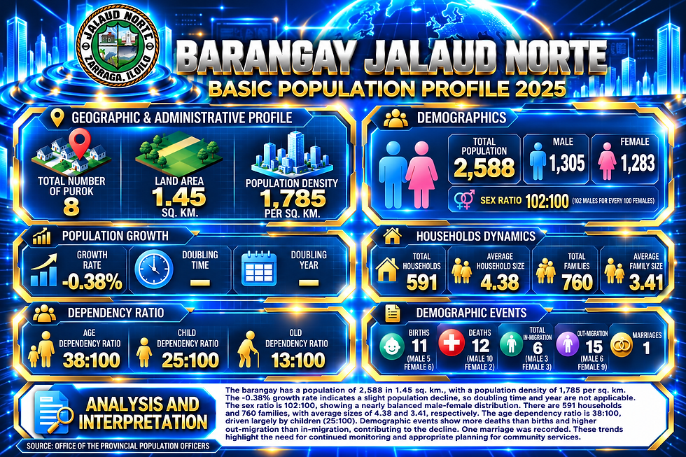
Barangay Jalaud Norte, situated in the northeastern section of Zarraga, Iloilo, occupies a compact portion of the municipality. This community thrives within a land area of 1.45 square kilometers, reflecting a high population density that benefits from local accessibility. The recent 2025 population records show a total population of 2,588 residents with 591 households and 760 families.
It is bounded on the North by the Municipality of Pototan, on the South by Barangay Jalaud Sur and Balud I, on the East by the Municipality of Dumangas, and on the West by the brink of Sigangao Creek to the Barangay Talibong.
Strategically, it serves as Zarraga’s second commercial center and a critical entry point and northern transit corridor connecting neighboring municipalities directly to the Zarraga trade area.
In terms of Connectivity, the barangay enjoys stable connectivity, situated 5 kilometers away from the town proper (poblacion). This positioning ensures resident access to vital municipal resources, medical institutions, schools, and markets. Commuters rely on traditional and modernized jeepneys for inter-municipal travel along the national route, connecting Zarraga to the adjacent trade centers of Pototan and Dumangas. For localized, point-to-point transit, tricycles serve as the vital primary link between the highway, inner residential zones, and the town proper.

Location Map

Barangay Jalaud Norte
Population Pyramid

Barangay Jalaud Norte
Population Profile